um;...
where am i?
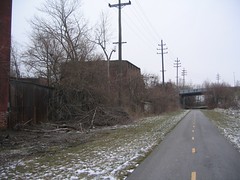
i took off for a ride today. i went down to the metroparks mtn bike trail; i figured that it was going to be closed, and it was. so i was thinking of how to get home other than just turning around. my mind wondered to taking the path that lead me to harvard, and go from there.
i got up to harvard, and noticed that the trail continued to what is called washington reservation. now...i don't get that north/eastish way, so i never knew that it was there. so i took that. next thing i knew i was heading north on east forty-ninth street. then that to what was called mill run. the next thing i knew...i was at harvard and union; going east. i finally turned around at east eighty-eighth.
for those of you not familiar, this is not the best part of cleveland to be in. esp. for a guy riding a bike all decked out in winter gear. i might have taken it all the way, if i had a bike with gears. the headwind was getting to me, and i was on fixed today. but there is always another time. gears, and a nine.
amitabha...
p.s.; after i posted this, i did some research from one of my other photos, and found this from the cleveland planning commission; which gives me more of an idea of where i was.
thanks.
posted by hamad at
Saturday, February 21, 2009
![]()


2 Comments:
Paul - funny you mention this. I just ran across this path last week as I was heading down Aetna Rd. on my way to Broadway for a tax clinic. All of a sudden, I see signs for bikes and then a path in a place I certainly wasn't expecting. I noted the cross streets and hit google earth when I got home, and traced it from start to finish. I found that same planning page from the city, too. Maybe we should give it a shot and see how several people in bike get-up fare in that part of town...
well...for the area i have to say that it was pretty clean. i do want to ride the full thing one day. does it connect with garfield?
Post a Comment
Subscribe to Post Comments [Atom]
<< Home